
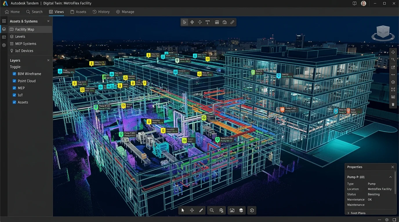
Core Capabilities & Autodesk Tandem Deliverables
From millimeter-precise on-site laser scanning to parameter-rich Revit and IFC models, our outputs are engineered for immediate ingestion into Autodesk Tandem workspaces.
3D Laser Scanning
High-accuracy LiDAR capture of facilities, MEP risers, plant rooms, and building architecture using Matterport Pro3 and Leica scanners. Eliminates site measurement errors and establishes accurate ground truth.
- Sub-centimeter spatial accuracy
- Up to 100m capture radius
- HDR 360° visual panoramas
- Millimeter geometric fidelity
Point Clouds
High-density registered point clouds formatted for direct intake into Autodesk ReCap, Revit, and Tandem reference viewers. Cleaned, indexed, and coordinate-aligned for zero geometric drift.
- Autodesk ReCap .RCP/.RCS native
- Unstructured & structured .E57
- Cleaned noise & ground classification
- Real-world coordinate georeferencing
BIM Modeling
Parametric Revit and IFC4 models built to LOD 200–350 and pre-tagged with COBie, UniFormat, and custom asset metadata schemas specifically mapped for Autodesk Tandem facility templates.
- Autodesk Revit .RVT LOD 200-350
- OpenBIM IFC4 Certification
- COBie & OmniClass asset schema
- Space boundary & level tagging
3D Meshes & CAD
Textured photorealistic 3D spatial meshes and accurate layered 2D/3D AutoCAD drawings. Ideal for lightweight spatial visualization, exterior site context, and floor plan asset registers.
- Textured OBJ/FBX spatial meshes
- Layered AutoCAD DWG floor plans
- Gross Internal Area (GIA) schedules
- CAD to BIM conversion workflows
How We Feed Autodesk Tandem
A disciplined, 4-step pipeline designed to bridge raw physical assets with operational digital twins without friction.
Value Proposition & Operational Use Cases
Why owner-operators, asset managers, and AEC leaders choose Digital Strada for Autodesk Tandem readiness.
Owner-Operator Handovers
Replace disconnected paper binders and PDFs with a unified, cloud-hosted digital twin. Hand over verified 3D assets with maintenance manuals, warranty info, and manufacturer specs linked directly to spatial objects.
Facility Operations & Maintenance
Empower facility management teams to instantly locate equipment, trace mechanical runs behind drywall, and pull maintenance history in seconds, reducing asset troubleshooting time by up to 60%.
Space Management & Leasing
Access verified Gross Internal Area (GIA) and Net Internal Area (NIA) measurements. Plan reconfigurations, tenant fit-outs, and space utilization with 100% spatial confidence.
IoT Asset Mapping & BMS Telemetry
Connect live IoT sensor streams—temperature, humidity, vibration, power draw, and air quality—directly to Tandem 3D spatial elements for real-time anomaly detection and predictive maintenance.
Structured Parameter Mapping for Autodesk Tandem
We configure your BIM elements with standardized metadata schemas that map directly into Tandem facility templates:
Spatial Hierarchy
- Facility ID & Campus Name
- Level / Floor Elevation
- Room / Space Boundary
- Zone / Occupancy Classification
Asset Identification
- Unique Asset Tag / Serial ID
- OmniClass / UniClass Code
- MasterFormat / UniFormat ID
- System / Sub-System Tag
Operational Data
- Manufacturer & Model Number
- Installation / Commissioning Date
- Warranty Expiration & Provider
- COBie Type & Component Specs
IoT & Telemetry Binding
- BMS Controller Reference ID
- Live Sensor Stream Keys
- Operating Thresholds (Min/Max)
- Maintenance Schedule Webhooks
Actionable 3D Scan Add-Ons & Engineering Deliverables
Extract structured CAD/BIM data, high-density point clouds, and instant insurance loss sketches directly from our Matterport Pro3 High-Density 3D LiDAR scan data.
Schematic 2D/3D Floor Plans
PDF | PNG | SVG2D schematic floor plans with room labels, precise wall dimensions, and Gross Internal Area (GIA) calculations delivered within 24-48 hours.
BIM File Bundle (Revit & IFC)
.RVT | .IFC OpenBIMAs-built 3D Building Information Models containing structural elements, walls, slabs, windows, doors, and MEP systems modeled directly from 3D scan data.
e57 Registered Point Cloud
.E57 (ASTM E2807 Standard)High-density LiDAR point clouds containing 3D spatial coordinates, RGB color data, and sensor origin positions for complex BIM & CAD reverse engineering.
MatterPak™ Data Bundle
.XYZ | .OBJ Mesh | Floor Plan PNGComplete architectural data bundle containing colored point clouds, 3D mesh OBJ files, ceiling plans, and high-resolution floor plans for direct CAD import.
AutoCAD Compatible 2D/3D CAD
.DWG | .DXFClean, layered architectural CAD floor plans, structural section cuts, roof plans, and exterior building elevation drawings fully compatible with AutoCAD & BricsCAD.
TruePlan™ for Xactimate
.SKX Xactimate SketchTurnkey 3D insurance claim sketches delivered directly into Xactimate for rapid property loss estimation and insurance claim adjustments.
Seamless Autodesk Construction Cloud & Revit Workflow Integration
Digital Strada provides professional on-site 3D LiDAR scanning services and extracts ready-to-import Autodesk deliverables (.RVT, .IFC, .DWG, .E57, .RCP). We assist your engineering team in seamlessly connecting these 3D scans and BIM models directly into your existing Autodesk Construction Cloud (ACC) or BIM 360 project workspaces.
Autodesk Construction Cloud (ACC) & BIM 360 Connect
We help you connect our captured 3D digital twins and spatial data directly into your ACC project dashboard. Embed 3D walkthroughs as Partner Cards and align spatial RFIs.
Revit As-Built BIM Modeling (.RVT / .IFC)
We convert raw 3D LiDAR point clouds into parametric Autodesk Revit (.RVT, .IFC) models from LOD 200 up to LOD 350 for MEP, structural, and architectural design.
AutoCAD & Civil 3D Drawings (.DWG / .DXF)
We deliver clean, layered 2D floor plans, section cuts, roof plans, and building elevations ready for instant import into your AutoCAD and Civil 3D software.
Autodesk ReCap Pro Point Clouds (.RCP / .RCS)
High-density LiDAR point clouds (.E57, .XYZ) indexed for Autodesk ReCap Pro (.RCP/.RCS) to enable millimetric clash detection in Navisworks and Revit.
How Digital Strada Implements 3D Scans & Deliverables into Your Autodesk ACC Workflow:
On-Site 3D LiDAR Reality Capture
Digital Strada deploys high-speed Matterport Pro3 LiDAR scanners to capture your building or jobsite with ±20mm @ 10m spatial tolerance and up to 100m range.
Turnkey Autodesk Deliverable Extraction
Our BIM engineers process raw scan data and extract ready-to-use Revit models (.RVT LOD 200-350), AutoCAD drawings (.DWG), and ReCap point clouds (.RCP).
Direct Import into Client ACC & Autodesk Docs Account
Your project team receives structured Autodesk files to upload directly into your existing Autodesk Construction Cloud (ACC Docs / BIM 360) repositories.
Live 3D Dashboard Embedding & Workflow Setup
We assist your team in embedding the interactive 3D digital twin into your ACC Partner Cards dashboard for remote inspections and clash coordination.
How AEC Teams Benefit from Our Autodesk Implementation:
Configure Your 3D Scanning, Scan to BIM & Software Proposal
Select your project area, space parameters, preferred currency, and required engineering deliverables below for a tailored technical proposal benchmark.
Configured Scope Summary
Need a Tailored Capture & Digital Twin Strategy?
Whether you are an owner-operator preparing for handover or an AEC firm delivering an Autodesk Tandem twin, Digital Strada provides end-to-end reality capture and asset modeling.