
Security Camera & Parking Enforcement 3D Scanning
Simulate exact CCTV & ANPR camera fields of view (FOV), eliminate license plate capture blindspots, and engineer mounting positions inside millimetric 3D digital twins before drilling a single bracket.
Parking Facility CCTV & ANPR Deliverable Specifications
- Camera FOV & Sightline Frustum Modeling: Precise 3D optical cone simulation (±20mm @ 10m) preventing beam, column, and signage occlusion.
- ANPR / LPR Capture Angle Audits: Mathematical validation of vertical and horizontal incidence angles (<30°) for 99.9% read rates.
- Virtual Pre-Installation & Cable Conduit Routing: Exact bracket heights, PoE drop distances, and junction box placements without physical site revisits.
Parking Enforcement Package
Zero-disruption LiDAR capture for multi-deck structures, underground garages, surface lots, and barrier entry lanes.
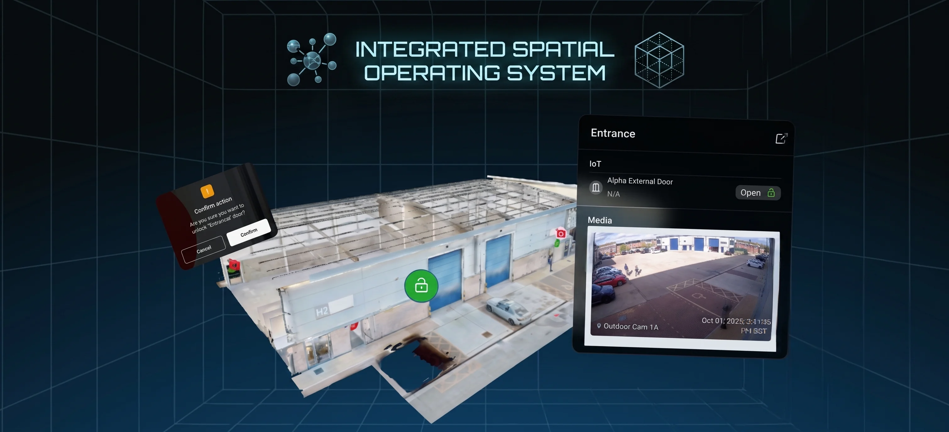
Integrated Spatial Operating System for Security Camera Parking Enforcement and 3D Scanning
A unified 3D spatial intelligence environment bridging physical parking structures and Video Management Systems (VMS). Correlate millimetric LiDAR point clouds, simulated camera frustums, live IoT sensor telemetry, and ANPR recognition geometry in a single, high-performance interface.
Optical Frustum & Sensor Simulation
Model 2.8mm, 4mm, 6mm, and PTZ optical cones inside the point cloud to verify pixel density (DORI / PPM) and eliminate structural occlusion before hardware purchase.
ANPR / LPR Capture Verification
Audit horizontal and vertical incident angles (<30°) and distance thresholds to prevent headlight flare, glare, and vehicle truncation.
Clearance & Obstruction Matrix
Map low-hanging HVAC ducts, concrete columns, structural beams, and signage to eliminate coverage gaps and blindspots.
Enterprise VMS Synchronization
Seamless integration with Milestone, Genetec, and central Security Operations Center (SOC) networks via georeferenced 3D asset tags.
Explore the Parking & Facility 3D Digital Twin
Inspect vehicular lanes, gate barriers, structural columns, and camera sightlines in millimetric 3D space.
High-Precision 3D Engineering for Security & Parking Operators
Virtual Camera FOV & Lens Simulation
Model 2.8mm, 4mm, 6mm, and varifocal PTZ lenses directly inside the 3D point cloud to verify pixel density (DORI / PPM) before procurement.
ANPR / LPR Capture Angle & Glare Auditing
Calculate precise vertical and horizontal incidence angles (<30°) and distance thresholds to prevent headlight washout and plate truncation.
Structural Obstruction & Clearance Mapping
Detect hidden blindspots caused by concrete pillars, low-hanging parking signage, HVAC ducting, and vehicular height clearance bars.
Virtual Pre-Installation & Bracket Mounting
Determine exact mounting heights, wall/ceiling bracket extensions, and drill points inside the twin to eliminate physical rework and lift re-rentals.
Multi-Deck & Underground Garage Mapping
Capture comprehensive spatial geometry across ramps, spiral access ways, payment kiosks, and pedestrian egress corridors in one unified model.
SOC & VMS Digital Twin Integration
Export spatially referenced camera coordinates and as-built asset tags into Milestone, Genetec, or custom Video Management Systems (VMS).
Actionable 3D Scan Add-Ons & Engineering Deliverables
Extract structured CAD/BIM data, high-density point clouds, and instant insurance loss sketches directly from our Matterport Pro3 High-Density 3D LiDAR scan data.
Schematic 2D/3D Floor Plans
PDF | PNG | SVG2D schematic floor plans with room labels, precise wall dimensions, and Gross Internal Area (GIA) calculations delivered within 24-48 hours.
BIM File Bundle (Revit & IFC)
.RVT | .IFC OpenBIMAs-built 3D Building Information Models containing structural elements, walls, slabs, windows, doors, and MEP systems modeled directly from 3D scan data.
e57 Registered Point Cloud
.E57 (ASTM E2807 Standard)High-density LiDAR point clouds containing 3D spatial coordinates, RGB color data, and sensor origin positions for complex BIM & CAD reverse engineering.
MatterPak™ Data Bundle
.XYZ | .OBJ Mesh | Floor Plan PNGComplete architectural data bundle containing colored point clouds, 3D mesh OBJ files, ceiling plans, and high-resolution floor plans for direct CAD import.
AutoCAD Compatible 2D/3D CAD
.DWG | .DXFClean, layered architectural CAD floor plans, structural section cuts, roof plans, and exterior building elevation drawings fully compatible with AutoCAD & BricsCAD.
TruePlan™ for Xactimate
.SKX Xactimate SketchTurnkey 3D insurance claim sketches delivered directly into Xactimate for rapid property loss estimation and insurance claim adjustments.
Enterprise Software Systems & Platform Implementations
We don't just deliver 3D scans. Digital Strada provides enterprise software integration, custom API development, IoT sensor telemetry, and AI spatial guide avatars across industry-leading platforms.
3D Smart Building IoT & 4D Construction Timeline
Smart Building 3D IoT facility management platform & 4D construction milestone progress tracking.
- Live BMS, HVAC, energy, and occupancy IoT sensor telemetry in 3D
- 4D timeline comparison between planned BIM models and physical scans
- Enterprise software licensing, setup, and custom API integration
Matterport Enterprise & Pro3 LiDAR
High-density 3D spatial reality capture (±20mm @ 10m), structured E57 point clouds, and custom SDK/API development.
- Pro3 LiDAR scanning with up to 100m range, 100,000 pts/sec rate, under 20s sweeps, and ±20mm @ 10m precision
- High-density point cloud extraction (.E57, .XYZ) and 3D Mesh (.OBJ)
- Mattertag asset tagging and custom Matterport Core SDK/API embedding
24/7 AI Spatial Guide & AR Connected Worker System
24/7 AI conversational virtual guide avatars, AR smart glass telemetry, and live video sales tours.
- Conversational AI virtual guide avatars active 24/7 inside 3D space
- Generative AI interior redesign and mobile camera AR indoor wayfinding
- AR smart glass telemetry and spatial safety warnings for plant workers
AutoCAD & Revit Compatible As-Built Deliverables
As-built spatial data conversion into BIM (.RVT, .IFC) and CAD (.DWG, .DXF) files fully compatible with AutoCAD, Autodesk Revit, and major AEC software.
- As-built 2D CAD drawings (.DWG, .DXF) compatible with AutoCAD for architects & engineers
- As-built Revit BIM models (.RVT, .IFC OpenBIM) built up to LOD 350 for AEC design teams
- Precise spatial geometry extracted from 3D LiDAR point cloud scans ready for AEC software
White-Label Enterprise 3D Viewport Overlays
Custom corporate UI navigation skins, multi-language switching, audio guides, and gated access.
- White-label brand skin customization with custom menus, logos, and fonts
- Multi-language language switching directly inside the 3D model viewport
- Background audio guides, password protection per room, and deep-linked tags
Procore Construction Management Integration
Embed Matterport 3D digital twins and spatial deliverables directly into client Procore project workspaces for unmatched visual site context and issue resolution.
- Attach RFIs, Observations, and Punch List items directly onto 3D Matterport spatial tags inside Procore
- Streamline construction closeout and quality control with a single 3D visual source of truth
- Turnkey delivery of Matterport add-ons (.RVT Revit BIM models, .E57 point clouds, MatterPaks) directly to client Procore accounts
Autodesk Construction Cloud (ACC) & Revit Integration
Integrate 3D LiDAR reality capture and Scan-to-BIM deliverables directly into Autodesk Docs, Build, BIM 360, and Revit for accelerated AEC workflows.
- Autodesk Build 3D RFIs & Observations: Pin jobsite issues to exact 3D spatial coordinates inside ACC
- Autodesk Docs & BIM 360 Partner Cards: Centralized 4K spatial digital twin visibility on project dashboards
- Autodesk Revit (.RVT) & ReCap (.E57): Direct point cloud & parametric BIM import up to LOD 350
Property Sites & Mobile AR Module
Turnkey single-property marketing web page with built-in lead generation forms and mobile AR Quick Look previewing 3D property assets on smartphones.
- Schematic 2D/3D floor plans with Gross Internal Area (GIA) calculations
- Single property marketing web landing pages with lead capture forms
- Mobile AR Quick Look 3D product placement for retail & real estate
Configure Your 3D Scanning, Scan to BIM & Software Proposal
Select your project area, space parameters, preferred currency, and required engineering deliverables below for a tailored technical proposal benchmark.