
Museums & Heritage
Crawfordsburn Beach & Country Park - Coastal 360° Virtual Tour
Crawfordsburn, Northern Ireland• Area: 320,000 m²
360° Coastal PhotogrammetryGoogle Maps Street ViewMarine Heritage MappingHDR Panoramas
Request Similar 3D ScanProject Overview
Building Background & Context
Crawfordsburn Country Park features two of Northern Ireland's most popular sandy beaches, ancient woodland glens, and panoramic coastal walking paths along Belfast Lough. Digital Strada mapped the shoreline in 360°.
🎯 The Challenge
High contrast between sea horizon, wooded cliffs, and shifting tidal sands.
💡 The Technical Solution
Time-calibrated 360° spherical HDR capture along beach promenades and wooden coastal boardwalks.
Project High-Res Photo Gallery
1 photos & 3D spatial captures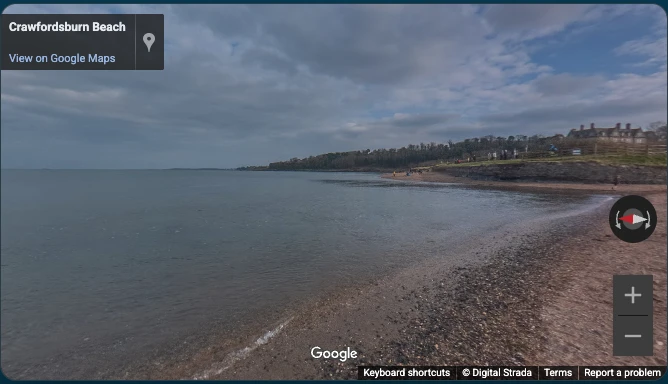
Crawfordsburn Beach & Country Park - Coastal 360° Virtual Tour - High-Resolution 360° Photogrammetry & Viewport
📦 Deliverables Produced for Client
- Coastal 360° Virtual Walkthrough
- Google Street View Beach Integration
- High-Resolution HDR Panoramas
- GIS Shoreline Records
Measurable ROI
Client Value & ROI Achieved
80,000+ Annual views on Google Maps
Showcasing coastal beauty for international tourists
Virtual accessibility for coastal walkers
Have a Similar Space to Scan?
We provide high-precision Matterport Pro3 LiDAR scanning, Scan-to-BIM, and custom software integrations globally.
Start Your 3D ProjectRelated Reality Capture
Featured 360° Tours & Spatial Projects


Custom 3D Engineering Proposal & Scope Builder
Configure Your 3D Scanning, Scan to BIM & Software Proposal
Select your project area, space parameters, preferred currency, and required engineering deliverables below for a tailored technical proposal benchmark.
m²
50 m²2,500 m²5,000+ m²
Tailored Engineering & Spatial Consultancy
Configured Scope Summary
250 m² • Commercial Office / Retail Space
⚡ Calculated Scope Analysis:
Custom Engineering Proposal
* 3D & BIM projects are tailored based on site parameters, timeline, and custom specifications.
🛒 Selected Scope Deliverables:
2D Schematic Floor Plan (GIA)
All project data is strictly confidential and routed directly to Digital Strada Team.